
This page is part of © FOTW Flags Of The World website
Grootegast (The Netherlands)
Groningen province
Last modified: 2003-06-28 by jarig bakker
Keywords: grootegast | tasman |
Links: FOTW homepage |
search |
disclaimer and copyright |
write us |
mirrors
 Shipmate Flagchart : http://www.shipmate.nl/flags.htm
adopted 3 Sep 1991
See also:
Grootegast municipality
Number of inhabitants (1 Jan 2003): 12.274; area: 88,29 km². Settlements:
Grootegast (seat), Doezum, Enumatil (part), Faan, Kornhorn, Lutjegast,
Niekerk, Oldekerk, Opende, Sebaldeburen
Grootegast is in southwest Groningen, where the borders of Groningen,
Friesland and Drenthe meet. It is a rural area - 'gast' meaning:
sandy soil. Abel Tasman, the 17th century discoverer of New Zealand, was
born in Lutjegast within Grootegast municipality. On 1 Jan 1990 Grootegast
merged with Oldekerk to form the new municipality of Grootegast.
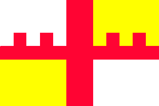
The horizontal red bar with pinnacles refers to the castle on the CoA,
which was that of Langewold, a division of the old region of
'Westerkwartier'; the castle refers to the castle in Sebaldeburen,
the old capital of Langewold.
Jarig Bakker, 8 November 1999
Grootegast CoA
![[Grootegast CoA]](../images/n/nl-gr)gg.gif) image from the Grootegast municipal
website.
image from the Grootegast municipal
website.
Granted 2 Feb 1889.
Oldekerk former municipality
![[Oldekerk flag]](../images/n/nl-gr_ok.gif) Shipmate Flagchart : http://www.shipmate.nl/flags.htm
Shipmate Flagchart : http://www.shipmate.nl/flags.htm
adopted 27 Mar 1967; in use 1967-1990.