
This page is part of © FOTW Flags Of The World website
Het Bildt (The Netherlands)
Fryslân province
Last modified: 2004-03-06 by jarig bakker
Keywords: het bildt |
Links: FOTW homepage |
search |
disclaimer and copyright |
write us |
mirrors
 Shipmate Flagchart : http://www.shipmate.nl/flags.htm
adopted 29 June 1955
Other Bilker pages:
See also:
Het Bildt municipality
Number of inhabitants (1 Jan 2003): 10.545; area: 116,48 km². Settlements:
Sint
Annaparochie (seat), Minnertsga, Oude Bildtzijl,
Sint Jacobiparochie, Vrouwenparochie,
Westhoek.
Minnertsga (Minnertsgea) was added in 1984, after the former municipality
of Barradeel was dissolved.
This municipality is a 'polder' in the old Middelzee, which in olden
days nearly split the present province of Friesland in half. Starting 1505
the sea made place for land. Building the dikes was mostly done by people
from South Holland, most of whom stayed there and until now they have retained
their own dialect ('Bilkerts').
Sierksma in 'Nederlands Vlaggenboek', 1962 [sie62]
writes:
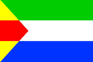
This flag was adopted on 29 June 1955 by municipial decree. The tripartition
points at the three original parishies in this area; the trangle at the
geographical form of this polder which was diked by Hollanders (from which
the colors of Zuidholland). The colors have been
derived too from the municipal COA: bottom white and blue reminds of the
COA of Westergo. The image of the flag
shows the geographical situation: the triangular polder in the mouth of
the old Middelzee (white), between the so-called Oudland (blue) and the
'Nijlân' (new land - green). Moreover one encounters in this flag
the colors of Oude Leije (RYB) and
Oude
Bildtzijl (VWR), whose flags are on Hesman's manuscript of 1708.
Jarig Bakker, 21 May 1999
Het Bildt CoA
![[Het Bildt CoA]](../images/n/nl-fr)hb.jpg) image from the municipal site.
image from the municipal site.
adopted 23 Apr 1919.