
Last modified: 2005-12-17 by bruce berry
Keywords: colonial flag | kionga triangle |
Links: FOTW homepage |
search |
disclaimer and copyright |
write us |
mirrors
image
by
António Martíns-Tuválkin, 13 Apr 2005
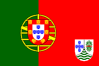
The Portuguese colonies were regarded as integral parts of Portugal
and did not have flags of their own. However, there were flags for the
Portuguese governors and Governors-General of the overseas provinces. There
was a project to give the Portuguese colonies/overseas provinces distinctive
flags, but these were never adopted. The pattern for these flags was a Portuguese
flag with the shield of the coat of arms of the territory in the lower fly,
as shown above. These coats of arms were already in existence, and the
shields of all consisted of two sub-shields, dexter representing the motherland,
sinister the territory, and the base the oceans between them. The sub-shield
of Mozambique was silver with seven green arrows pointing downwards, tied
together with a red ribbon.
Mark Sensen, 30 July 1996
It's interesting that the colonial flags of Mozambique relate only to
the Overseas Province of Mozambique, not to the previous dispensation under
the Kingdom of Portugal and the first three decades of the Portuguese Republic,
where what we today call Mozambique was a grouping of separate colonies,
labeled for convenience Portuguese East Africa.
These colonies were, from south to north, Lourenço Marques,
Inhambane, Manhica e Sofala (administered by the Companhia de Moçambique),
Quelimane and Tete (these last two were initially separate, then combined
as Zambezia), Moçambique and Niassa (Niassa administered by the
Companhia de Niassa).
All of them issued stamps (the chartered companies issued stamps for
the two under company administration), but I haven't yet seen any indication
of flags.
Mike Oettle, 20 Dec 2001
![[Colonists flag]](../images/m/mz^1974.gif) image
by
António Martíns, 21 Sep 1997
image
by
António Martíns, 21 Sep 1997
Currently kept in the personal collection of Dr. Whitney Smith, is a
"colonial" Mozambican flag which was made and hoisted in July 1974 by some fleeing
Portuguese colonialists in Lourenço Marques (now called Maputo),
consisting of a Portuguese flag design (2:3) with a background of green and red charged with the colonial greater
arms: a round point shield (7:8) tierced in mantel, dexter silver, five
blue eschuteons arranged in cross, each charged with five silver bezants
saltire (old Portuguese arms), sinister silver, seven green arrows pointing
down tied with a red tie, point silver, four waves of green (Portuguese
traditional heraldic sea). The shield rests on a large golden armillary
sphere (in this flag 1/2 of the hoist, as in the Portuguese national flag)
in an "art nouveau" perspective less style, crowned with a 5 tower golden
castle wall, with a blue armillary sphere on each tower and one silver
shield charged with an Order of Christ cross on each of the four crenel
gaps between the towers. Under all this a white scroll where the usual
black sans serif inscription "PROVÍN. PORTUGUESA DE MOÇAMBIQUE"
(before 1951: "COLÓNIA PORTUGUESA DE MOÇAMBIQUE") was substituted
to a plain "MOÇAMBIQUE".
António Martíns, 21 Sep 1997
- Placed in southern Mozambique is another square flag, yellow bordered
in blue, with a red templar cross in the yellow square. This is another Portuguese
flag unknown to me.
Jorge Candeias, 15 Aug 1999
This is correct concerning the Niassa Company, which handed its territory
(north of the River Lurio) back to the Portuguese Government on 27 October
1929. However, the Mozambique Company continued until the Second World
War, handing its territory (between the Save and Zambezi rivers) back in
January 1942. Unfortunately I also lack information on flag use, although
there might just be something I can glean (not in full colour, unfortunately)
from my Mozambique Company stamps. I'll have another look. I have no information
on the Zambezi Company, as this company did not issue its own stamps -
Portugal issued stamps for the colonies of Quelimane and Tete, and later
merged them as Zambezia.
Mike Oettle, 4 Jan 2002
About the end of these companies: yes -- I do not know exactly, but
I've heard that it is also related to the 1918 issue of the newly portuguese
ruled territory of the so called "Triangle of Rovuma", transferred from
German East Africa to Portuguese (Mozambique) after World War I.
António Martins, 31 May 1997
At first I couldn't find it, because the Stielers Handatlas of 1912
had the Rovuma river as northern border of Mozambique. In Andrees Handatlas
of 1910 the Rovuma triangle is clearly visible, named "Kionga", a district
known as the Kionga Triangle, northeast Mozambique, south of the
Rovuma river, 1.000 km2. Kionga town had (1910) 4.000 inhabitants;
formerly a part of German East Africa; occupied in 1916 by Portuguese troops,
transferred to Portugal 1919. I suppose only national flags of Germany
and Portugal were used in those days (although special postage stamps were
issued in 1916).
Jarig Bakker, 22 Oct 2002
![[Old Military Banner]](../images/m/mz^pt.gif) by
António Martins, 21 April 1998
by
António Martins, 21 April 1998